

Lake Wissota Stewardship Project
Clean Water. Bright Future.
About Us


The Lake Wissota Stewardship Project is a partnership between the Lake Wissota Association and the Land Conservation and Forest Management Department of Chippewa County, dedicated to supporting landowners in land and watershed conservation efforts through community engagement, education, and proactive environmental stewardship. Our areas of work include Lake Wissota as well as the Yellow River Watershed, Moon Bay, and Little Lake Wissota.
We encourage landowners in the watershed to continue to reduce runoff of nutrients into the lake by installing stream buffers, sediment basins, and other conservation practices on the land. Our recent emphasis has been planting cover crops—a farming practice that protects ground and surface water, improves soil quality, and reduces fertilizer costs—and monitoring the quality of streams entering the lake.
Current Projects

1
Water Quality Monitoring
Working with Beaver Creek, the DNR, and Water Action Volunteers, we monitor water flow, temperature, and bugs (macroinvertebrates) to keep track of our water quality as we implement our projects.
3
Runoff Pollution Prevention
We work with homeowners and volunteers to plant trees, install stream buffers and sediment basins, and restore wetlands – all to reduce the runoff of nutrients that feed lake algae.
Check out our Fixed Point
Photo Stations!
Anyone with a mobile phone can take photos of Lake Wissota at our Photo Stations! These stations are at a fixed point, meaning they won't ever move, and they help us keep track of algal conditions and other water quality issues. We use these photos to tack our progress over time as we and landowners implement projects within the watershed. Interns, staff, and volunteers go out at least once a month to photograph each site and upload it to a Story Map. Scroll down past the directions map to find the link if you want to see how the lake has changed each month since the stations were established in 2024!
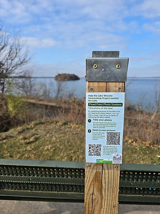
Search for the stand at each location, then follow the instructions to submit your photos.


Each stand has these instructions on or beside it!
Click here to view the story map!
